
Learn about the Murillo Velarde Map
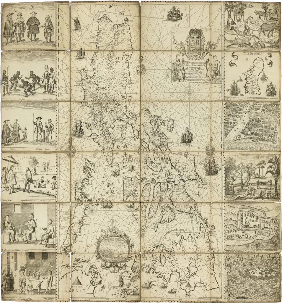
The Murillo Velarde Map of the Philippines, officially titled Carta Hydrographica y Chorographica de las Yslas Filipinas, is one of the most important historical documents ever produced about the Philippine archipelago. Published in Manila in 1734, the 1734 Murillo Velarde Map is widely recognized as the first scientific map of the Philippines. Unlike earlier maps that often relied on incomplete reports or secondhand information, this remarkable work drew upon more systematic geographic surveys, navigational records, and information gathered by Spanish officials, missionaries, sailors, and local communities throughout the islands. Nearly three centuries after its publication, the Murillo Velarde 1734 Map continues to serve as an invaluable resource for historians, geographers, linguists, educators, and legal scholars seeking to understand the country’s historical geography and cultural heritage.
Who Created the Murillo Velarde Map?
Pedro Murillo Velarde and His Collaborators
The Murillo Velarde Map was compiled by Pedro Murillo Velarde (1696–1753), a Spanish Jesuit priest, historian, geographer, and professor who spent many years in the Philippines. Because of his extensive contributions to Philippine geography, he is often called the “Father of Philippine Cartography.” His goal was to produce a more accurate representation of the archipelago than any previous map available during the Spanish colonial period.
Although Pedro Murillo Velarde served as the principal cartographer, the project was the result of a collaborative effort. The map was drawn by the Jesuit Francisco Suárez and engraved by Nicolás de la Cruz Bagay, a Filipino master engraver from Manila. Both Suárez and Bagay proudly signed the work as “Indio Tagalo,” demonstrating the significant role that native Filipino artists played in producing one of the greatest cartographic achievements in Philippine history.
Their combined expertise produced a map that blended scientific observation with exceptional artistic craftsmanship, making the Velarde Map both an accurate geographic reference and a work of art.
Why the 1734 Murillo Velarde Map Was Revolutionary
The First Scientific Map of the Philippines
The 1734 Murillo Velarde Map is considered revolutionary because it represented the most comprehensive and scientifically prepared map of the Philippine archipelago produced during the Spanish colonial era. Earlier maps often contained inaccuracies regarding island locations, coastlines, and settlements. Murillo Velarde’s work improved upon these earlier efforts by incorporating information from Spanish expeditions, missionary reports, navigational observations, and local geographic knowledge.
The finished map measures approximately 112 by 120 centimeters, allowing remarkable detail across the entire archipelago. Hundreds of islands, rivers, mountain ranges, bays, ports, and settlements are carefully identified. The map also illustrates important maritime routes connecting the Philippines with Mexico, China, and other parts of Asia through the Manila-Acapulco Galleon Trade.
For historians, the Murillo Velarde Map of the Philippines represents the most reliable eighteenth-century geographic portrait of the country.
Geographic Information Preserved in the Velarde Map
A Record of the Philippine Archipelago
One of the greatest strengths of the Murillo Velarde Map is its detailed depiction of Philippine geography. It identifies major rivers, mountain ranges, islands, lakes, and coastal features throughout Luzon, the Visayas, and Mindanao.
The map records hundreds of settlements existing during the early eighteenth century. Many of these communities continue to exist today, although their names have evolved over time. Because the map reflects Spanish spellings used in official records, it provides valuable evidence for historians studying the development of Philippine place names.
For example, the city of Tuguegarao appears on the 1734 Murillo Velarde Map as “Tubigarao.” This historical spelling has become an important reference for researchers investigating the origin and evolution of the city’s name. Similar examples can be found throughout the map, making the Velarde Map an important resource not only for geography but also for historical linguistics and local history.
The Artistic Features of the Murillo Velarde Map
More Than a Geographic Document
The Murillo Velarde 1734 Map is admired not only for its scientific accuracy but also for its artistic excellence. Surrounding the map are richly engraved illustrations that provide a glimpse into life in the Philippines during the eighteenth century.
The decorative side panels feature ethnographic illustrations depicting various peoples living across the archipelago. These images portray traditional clothing, occupations, customs, and everyday activities observed during the Spanish colonial period. They provide historians with valuable visual evidence of the country’s cultural diversity nearly three centuries ago.
The map also includes detailed views of Manila, Cavite, Samar, and Zamboanga, illustrating important settlements within the Spanish colonial administration. These city views reveal fortifications, churches, harbors, and urban layouts, making them valuable historical records in their own right.
Together, these artistic elements transform the Murillo Velarde Map of the Philippines into both a scientific publication and a visual encyclopedia of eighteenth-century Philippine society.
Historical Importance of the Murillo Velarde Map
Preserving Philippine History
Beyond its geographic accuracy, the Murillo Velarde Map serves as an irreplaceable historical record. Researchers frequently consult the map to reconstruct historical settlements, transportation routes, colonial administration, and regional development.
The map also documents the names used by Spanish authorities during the eighteenth century, allowing scholars to compare historical spellings with their modern counterparts. This information has contributed to numerous studies on Philippine history, linguistics, archaeology, and historical geography.
Because of its exceptional detail, the Murillo Velarde Map of the Philippines remains one of the primary references used when studying the country’s colonial landscape.
The Velarde Map and the West Philippine Sea Arbitration Case
A Valuable Historical Reference
The Velarde Map has gained renewed attention in recent decades because of its role in documenting the historical geography of the Philippine archipelago. During the Philippines’ efforts to defend its maritime rights before the Permanent Court of Arbitration in The Hague, the map was cited among numerous historical documents demonstrating how Spanish authorities understood the territorial extent of the Philippine archipelago during the eighteenth century.
It is important to note that while the Philippines submitted the Murillo Velarde Map as part of the historical evidence illustrating the country’s longstanding geographic connection to features in the West Philippine Sea, including Scarborough Shoal and parts of the Spratly Islands, the arbitral tribunal did not determine which country holds sovereignty over these disputed land features. Instead, the tribunal limited its ruling to maritime rights and obligations under the United Nations Convention on the Law of the Sea (UNCLOS).
Nonetheless, the Murillo Velarde 1734 Map remains an important document illustrating the long-standing geographic identity of the Philippines as a sovereign country. Today, the map continues to be studied by historians, legal scholars, and policymakers interested in the historical development of Philippine territory.
The Return of the Original Murillo Velarde Map
Bringing a National Treasure Home
Only a small number of original copies of the 1734 Murillo Velarde Map survive today. Original copies are preserved in institutions such as the Library of Congress, the British Library, the National Library of Spain, and the Bibliothèque nationale de France.
In 2014, one exceptionally well-preserved original copy was offered for sale at a Sotheby’s auction in London. Recognizing its importance to Philippine history, technology entrepreneur Mel V. Velarde successfully acquired the map to ensure that it would eventually return to the Philippines.
After conservation and legal arrangements, Mel V. Velarde formally turned over the original Murillo Velarde Map to the Philippine government. Today, the original 1734 Murillo Velarde Map is housed at the National Library of the Philippines in Manila, where it is carefully preserved under controlled conditions for future generations. Its return represents one of the most significant repatriations of a Philippine historical artifact in recent history.
Why the Murillo Velarde Map Still Matters Today
A Legacy for Future Generations
Nearly 300 years after its publication, the Murillo Velarde Map of the Philippines continues to influence historical research, education, and cultural preservation. Historians use the map to reconstruct colonial settlements and transportation networks. Geographers compare its depictions with modern maps to study changes in coastlines and landscapes. Linguists analyze its place names to understand the evolution of Philippine languages and spelling.
The Murillo Velarde Map also serves as an educational resource, helping students appreciate the complexity of Philippine geography during the Spanish colonial era. Its ethnographic illustrations and city views provide rare visual records of eighteenth-century Filipino society, making it valuable not only to scholars but also to museums and cultural institutions.
More than a beautifully engraved chart, the Murillo Velarde 1734 Map remains a symbol of the Philippines’ rich historical heritage. It reminds modern Filipinos that maps are more than navigational tools—they are historical records that preserve geography, culture, language, and identity across generations.
References
Cultural Center of the Philippines. “Murillo Velarde Map of 1734.” CCP Encyclopedia of Philippine Art Digital Edition. November 18, 2020. Accessed July 30, 2026.
https://epa.culturalcenter.gov.ph/3/82/2233/
Library of Congress. A Hydrographical and Chorographical Chart of the Philippine Islands (Carta Hydrographica y Chorographica de las Yslas Filipinas). Manila, 1734. Accessed July 30, 2026.
https://www.loc.gov/item/2021668467/
Library of Congress. Carta Hydrographica y Chorographica de las Yslas Filipinas. Manila, 1734. Accessed July 30, 2026.
https://www.loc.gov/item/2013585226/
National Library of the Philippines. National Library of the Philippines Newsletter, Vol. 16, Issue IV (October–December 2024). “Historic Murillo Velarde Map Inspires Cultural and National Pride.” Accessed July 30, 2026.
https://web.nlp.gov.ph/wp-content/uploads/2025/01/NLP-Newsletter-2024-4Q-compressed.pdf
Permanent Court of Arbitration. The South China Sea Arbitration (The Republic of the Philippines v. The People’s Republic of China), Award of 12 July 2016. The Hague: Permanent Court of Arbitration, 2016. Accessed July 30, 2026.
https://pca-cpa.org/en/cases/7/